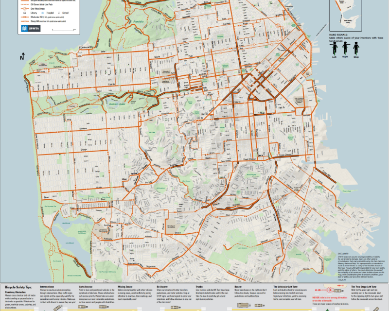
Skip to content.
Skip to next level navigation.Skip to content.Website accessibility
SF MTA homeSF MTA home SF MTA home
 Muni logo
A section of the Muni downtown map, part of the official map

Maps

America's Cup service Oct. 4 to 7, 2012

Muni’s Street & Transit Map is a comprehensive guide to public transit in the city.  The map may be purchased for $3.00 at various locations, including the Muni kiosks at the Powell & Market and Beach & Hyde cable car terminals and most everywhere in town that sells books and periodicals.  A version of the map can be viewed at most Muni bus shelters and in Muni Metro stations; the system map can also be viewed on this website, along with specialized maps.

The following types of maps are available for viewing on this website:

Sample Image
Description
System maps thumbnail image of Muni system map Maps showing the entire Muni system
Metro maps thumbnail image of Muni Metro map Maps showing the Muni Metro system, rail lines which serve the Muni Metro subway
Stadium maps thumbnail image of sample stadium service map Maps showing access to AT&T Park and Candlestick Park
Individual lines and routes thumbnail image of sample individual route, 39 Coit Maps for each individual Muni rail line and bus route

Accessible route descriptions can be found in the Muni route guide.


Explore:

Follow SFMTA on Twitter

San Francisco 311 Customer Service CenterVisit the 311 Self-service portal

Shortcut to this page:

  • www.sfmta.com/maps


Skip bottom navigation and boilerplate text.Begin brief site navigation and boilerplate text.

For Muni route, schedule, fare and accessible services information anytime: Visit www.sfmta.com or call 311.

telephone311 Free language assistance / 免費語言協助 / Ayuda gratuita con el idioma / Бесплатная помощь переводчиков / Trợ giúp Thông dịch Miễn phí / Assistance linguistique gratuite / 無料の言語支援 / 무료 언어 지원 / Libreng tulong para sa wikang Tagalog / คว“มช่วยเหลือท“งภ“ษ“โดยไม่เส’ยค่าใช้จ่าย