Westside Circulation Study
In Spring 2021, the SFMTA and the Fehr and Peers consultant team conducted a comprehensive operational analysis to better understand impacts and pressure points in the circulation system as a result of the COVID-19 temporary closures of roads in Golden Gate Park and along the Great Highway. The summary memo linked in the sidebar contains “key findings” as well as the methodology. Staff plan to use the study to help identify solutions and to design project proposals that will address congestion in the network, improve safety and the overall functionality of the network which is responsive to resident’s concerns. Given the dynamic nature of the network, traffic conditions and the recovery, staff recommend that additional analysis, evaluation and monitoring be conducted on the westside network to better understand how the network is operating in late summer/fall as the city gradually recovers from COVID-19.
Traffic calming monitoring indicates a reduction in traffic volume and speed
In Spring 2021, staff installed an integrated network of traffic calming measures throughout the Outer Sunset to support the repurposing of the Great Highway as a car-free promenade. In June 2021, traffic speed and volume data was collected and analyzed to understand the effectiveness of the traffic calming measures. The findings indicate that 7 of 7 locations saw a decrease in traffic volume between January and June 2021 and that 7 of 7 locations saw a reduction in traffic speed. These findings indicate that the traffic calming measures were successful in helping to reduce both speed and volume throughout the Outer Sunset.
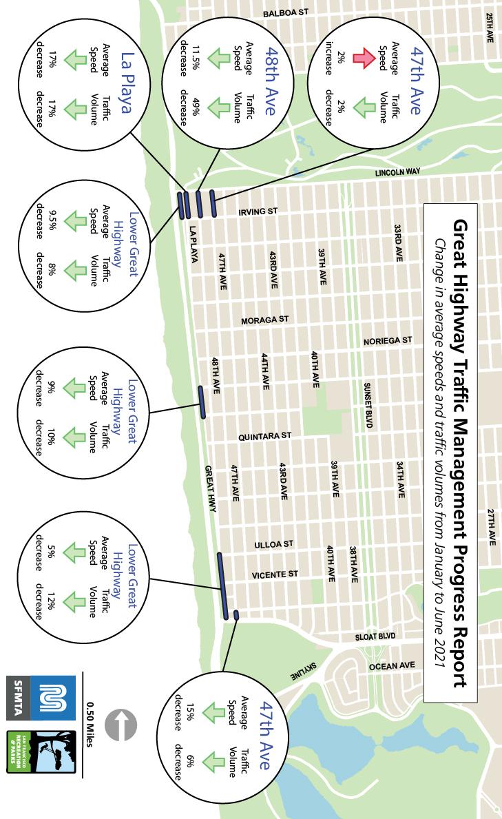
- Lower Great Highway between Lincoln and Judah: 10% decrease in average speed, 8% decrease in traffic volumes
- Lower Great Highway between Ortega and Pacheco: 9% decrease in average speed, 10% decrease in traffic volumes
- Lower Great Highway between Sloat and Ulloa: 5% decrease in average speed, 12% decrease in traffic volumes
- 48th Avenue between Lincoln and Judah: 12% decrease in average speed, 49% decrease in traffic volumes
- La Playa between Lincoln and Judah: 17% decrease in average speed, 17% decrease in traffic volumes
- 47th Avenue between Sloat and Wawona: 15% decrease in average speed, 6% decrease in traffic volumes
- 47th Avenue between Lincoln and Irving: 7% decrease in average speed, 3% decrease in traffic volumes