The results are in on San Francisco's first "home zone" project!
In 2014, we finished the Minna Natoma Home Zone Project, which took a holistic approach to making a six-block Mission District neighborhood safer and more walkable. We used raised crosswalks, speed humps, and roadway narrowing to create a “home zone” - a community-focused area where traffic calming measures put people first, whether they are walking, riding bicycles, or in a car.
You can see the results with this infographic and get a better sense of the project's history in the story that follows. You might also want to read our final evalution report.
Responding to Neighborhood Concerns
You’ve probably walked past the Mission’s smaller, residential streets like Minna, Natoma, 15th, Capp and Adair. Maybe you’ve biked down them or parked your car there too.
In 2012, the SFMTA saw the area in need of safety improvements. We also heard concerns from residents, families and the nearby Marshall Elementary School. What we saw and heard touched on a few key concerns, including:
- Speeding
- Reckless driving
- Pedestrian safety, especially for school children at crossings
- Truck traffic in alleys
- Red light running
With those concerns in mind, we secured local Proposition K funds from the San Francisco County Transportation Authority (SFCTA) to kick off San Francisco’s first “home zone” project.
Our goal with San Francisco’s first “home zone” was to create a more walkable neighborhood, using traffic calming measures to create a community-focused zone that puts people first, whether they are walking, riding bicycles, or in a car.
Designing Community Streets
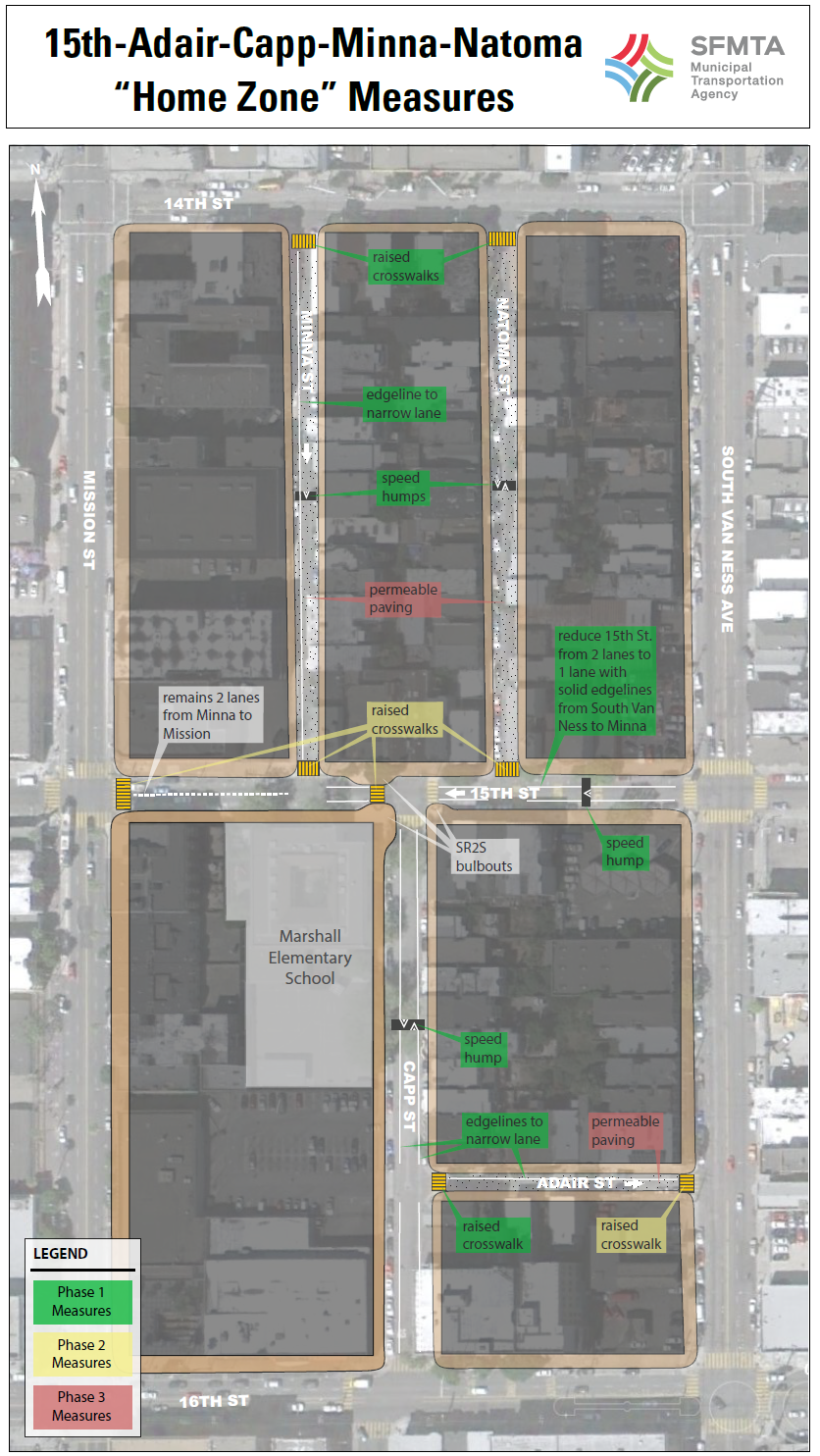
By 2014, we installed a variety of traffic calming tools that encourage cautious driving, including:
- Speed Humps – Three speed humps, one each on Minna, Natoma and Capp Streets, help reduce speeding.
- Edgelines – Edgelines use painted lines to narrow the road to bring down speeds. Edgelines reduced the travel lane width to 10 feet on Minna, Adair and 15th streets, and were also painted on Capp Street, reducing the roadway to 20 feet wide.
- Raised Crosswalks – Raised crosswalks protect pedestrians by causing vehicles to slow as they cross the intersection. In total, eight were installed in the project area.
- Lane Reduction – On 15th Street between South Van Ness and Mission, a lane reduction was installed in conjunction with edgelines to visually narrow the remaining lane of traffic.
- Bulbouts – By shortening crossing distances and increasing visibility for pedestrians, bulbouts increase safety. Three were installed at Capp and 15th Streets.
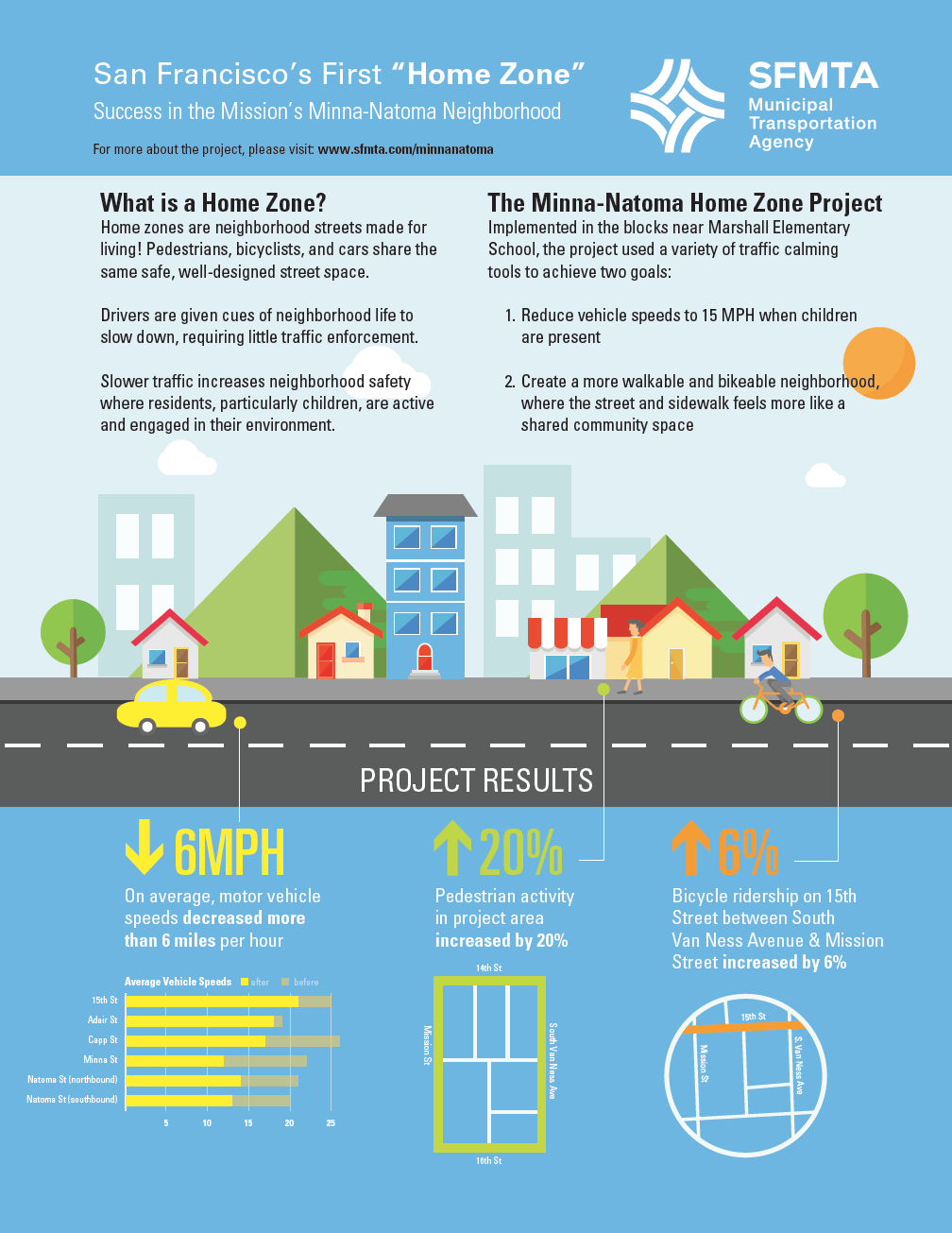
The Results Are In!
A key part of this project was measuring success, and success we had.
- On average, motor vehicle speeds decreased to below 20 miles per hour throughout the home zone area
- People feel that pedestrian safety has improved, with vehicles yielding to people walking and stopping at stop signs more than before
- More people are walking in the area. We’ve seen an average increase of 20%
- More people are bicycling in the area. On 15th Street between South Van Ness and Mission Street, we’ve measured an increase of 6%
NEXT STEPS
In San Francisco, just 12% of city streets account for more than 70% of our traffic crashes. We are working to fix this by focusing on improving safety on these streets, which we call the High Injury Network. All this is in support of Vision Zero, the city’s goal to eliminate traffic fatalities.
We’re still working to improve neighborhood safety, too. If you’re interested in traffic calming on your residential street, please check out our application-driven Traffic Calming Program!