
This project has been completed and is now archived. The information on this page reflects the status and outcomes of the project as of 2023. It may not reflect current conditions or future modifications. For up-to-date information on transportation projects and initiatives in San Francisco, please visit the SFMTA Projects page.
During the initial days of shelter-in-place, the 1 California saw significantly faster travel times east of Arguello Boulevard compared to pre-pandemic. But with traffic returning beginning in fall 2020, average speeds along the 1 California corridor decreased, slowing bus travel times and causing crowding and pass-ups.
In order to protect people who rely on transit from increased exposure to COVID-19 on slow or crowded buses, we acted quickly to install Temporary Emergency Transit Lanes on segments of the 1 California and other key routes where traffic bottlenecks occur. When buses aren’t competing with traffic, they can complete routes more quickly, providing more frequent service and greater capacity with the same number of buses.
The 1 California serves the Chinatown neighborhood–one of San Francisco's neighborhoods with high percentages of people of color and low-income households. 65% of Chinatown and Nob Hill households do not own a car, more than twice as many as the citywide average of 31%. Transit lanes help keep buses out of traffic so that essential workers and transit dependent San Franciscans don’t bear the costs of traffic congestion.
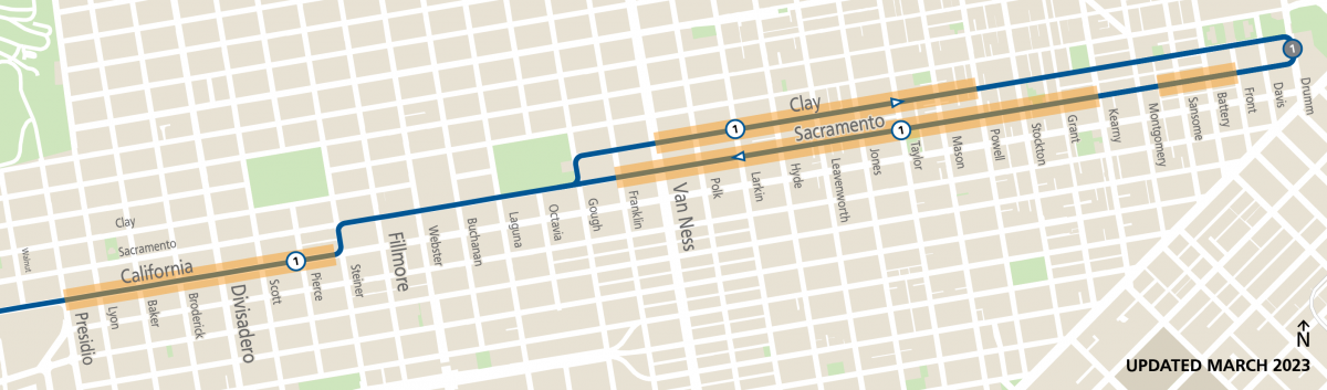
Map showing an overview of where new transit lanes were installed or hours of existing transit lanes were extended. Note that two blocks of transit lanes on Clay Street between Mason and Taylor and between Jones and Leavenworth will be installed later in 2023. View a detailed map here.
Temporary Emergency Transit Lanes Details
Temporary emergency transit lanes were approved in April 2021 and installed along segments of California, Clay and Sacramento streets. In January 2022, the project was approved to become permanent with some modifications.
- On California Street between Steiner and Presidio streets, transit lanes replaced the curbside travel lane. Lanes are in effect at all times. All on-street parking has been retained.
- On designated segments of Clay and Sacramento streets between Franklin and Kearny streets, transit lanes introduce new parking restrictions in the right-hand curbside parking lane during the hours the transit lane is in effect.
- On Sacramento between Leidesdorff and Front streets, converted the existing 7am-7pm transit lane to a full time transit lane, eliminating these spaces as part-time parking spaces.
- Two blocks of AM and PM peak transit lanes that were added to the project as part of the permanent legislation in 2022 on Clay Street, between Mason and Taylor and between Jones and Leavenworth, will be installed in 2023. Currently, there are trees overhanging into the curbside lane on these blocks that prevent a bus from operating. After the trees are replaced, bus lanes will be installed on these blocks.
- Two blocks of PM peak transit lanes on Clay Street between Powell and Grant streets are being removed following evaluation and public feedback.
The transit lanes were installed in mid-2021 and striped only with white paint and identified with “Bus/Taxi Only” stenciling and signage. Cars are still allowed to enter transit lanes to make right turns and access parking. Emergency transit lanes that were not permanently legislated were removed within 120 days after the emergency order was lifted.
On California Street
- Presidio Avenue* to Steiner Street: add 24/7 (all hours) transit lane
*Update as of 2/3/21: The project proposal was revised to remove the proposed transit lane on California Street between Arguello and Presidio. This change in scope is as a result of design work revealing inadequate roadway width for a transit lane in this segment.
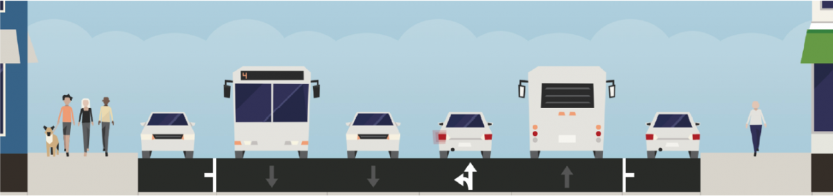
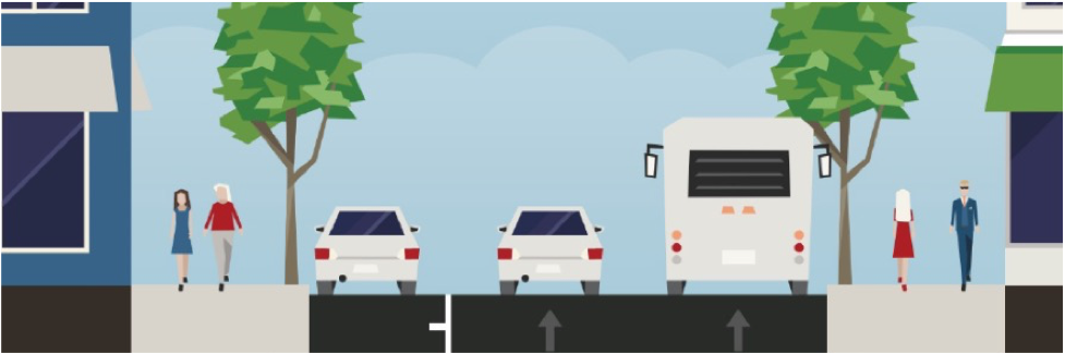
Cross-section showing street configuration of California Street between Presidio Avenue and Steiner Street, with the travel lane nearest to the curb converted to a 24/7 transit lane on each side of the street. Parking is retained.
Tow-Away Zones on Clay and Sacramento Streets
Based on outreach to the community and the feedback we received, the original proposals were revised to the following:
On Clay Street
- Morning AM Hours:
- Between Powell and Sansome: no changes to existing towaway hours
- Between Larkin and Leavenworth, Jones and Taylor, Mason and Powell: establish towaway hours from 7:00 a.m.-10:00 a.m
- Evening PM Hours:
- Between Grant and Front: no changes to existing towaway hours
- Between Powell and Mason: add 3:00 p.m.-7:00 p.m. towaway
- Between Jones and Taylor: add 3:00 p.m.-7:00 p.m. towaway
- Between Larkin and Leavenworth: add 3:00 p.m.-7:00 p.m. towaway
- Between Larkin and Van Ness: add 24/7 (all hours) transit lane
On Sacramento Street
- Morning AM Hours:
- Between Leidesdorff and Front: add 24/7 towaway (all hours)
- Between Kearny and Leidesdorff: no changes to existing towaway hours
- Between Larkin and Kearny: no changes to existing towaway hours
- Between Franklin to Larkin: add 24/7 transit lane
- Evening PM Hours:
- Between Leidesdorff and Front: establish 24/7 towaway (all hours)
- Between Larkin and Kearny: expand towaway hours to 3:00 p.m.-7:00 p.m.
- Between Franklin to Larkin: add 24/7 transit lanes
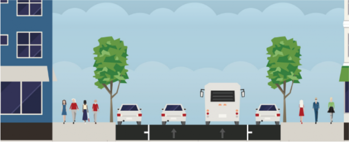
Cross-section showing street configuration of Clay and Sacramento streets between Franklin and Larkin streets. The travel lane next to the right-hand curb would be converted to a 24/7 transit lane. Parking would be retained.
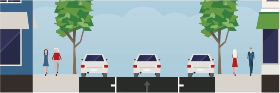
Cross-section showing street configuration for streets east of Larkin. Parking is retained on both sides of the street when bus lanes are not in effect.
Cross-section showing street configuration for streets east of Larkin. The curbside parking lane becomes a transit lane when bus lanes are in effect.
Outreach and Evaluation
We conducted extensive outreach throughout each phase of the project to seek input on transit improvements. Community-based organizations, stakeholders and neighbors were involved in shaping the framework for evaluating and adjusting the transit lanes as needed. Both qualitative and quantitative data were collected after implementation and continue to inform our evaluation of the project.
Below is a summary of the project timeline and outreach:
Mid to late 2020: Initial meetings were held with Chinatown, Nob Hill and Pacific Heights stakeholder groups.
Early 2021: Continued stakeholder meetings. Mailers, emails and posters were distributed along the corridor announcing the 1 California TETL proposal. Two online communitywide meetings were held—one focused on the west side of the corridor and one on the east side. Read a summary of the outreach and feedback received.
Spring 2021: The original temporary transit lanes proposal was revised based on community feedback, including dropping or reducing some transit lane hours/parking restrictions on several blocks. The SFMTA Board of Directors approved the new 1 California transit lanes on a temporary basis at their April 20, 2021 meeting.
June 2021: 1 California temporary transit lanes were installed.
August 2021: The SFMTA conducted an evaluation of the temporary transit lanes, including a walkthrough of the new lanes with Chinatown community members, and a survey promoted via postcards, posters, emails, social media ads and newspaper ads.
Fall 2021: The evaluation results were published, showing travel time improvements on the 1 California. A proposal to make the transit lanes permanent with some additional modifications was developed based on evaluation and public feedback. Virtual Office Hours were held to answer questions about the evaluation results.
January 18, 2022: The SFMTA Board approved making the temporary transit lanes permanent, with the exception of Clay Street between Stockton and Grant, which remained as a temporary transit lane pending further evaluation.
Spring 2023: Following additional outreach and evaluation, the temporary transit lane on Clay Street between Stockton and Grant was removed.
Learn more about the Temporary Emergency Transit Lanes program and evaluation.