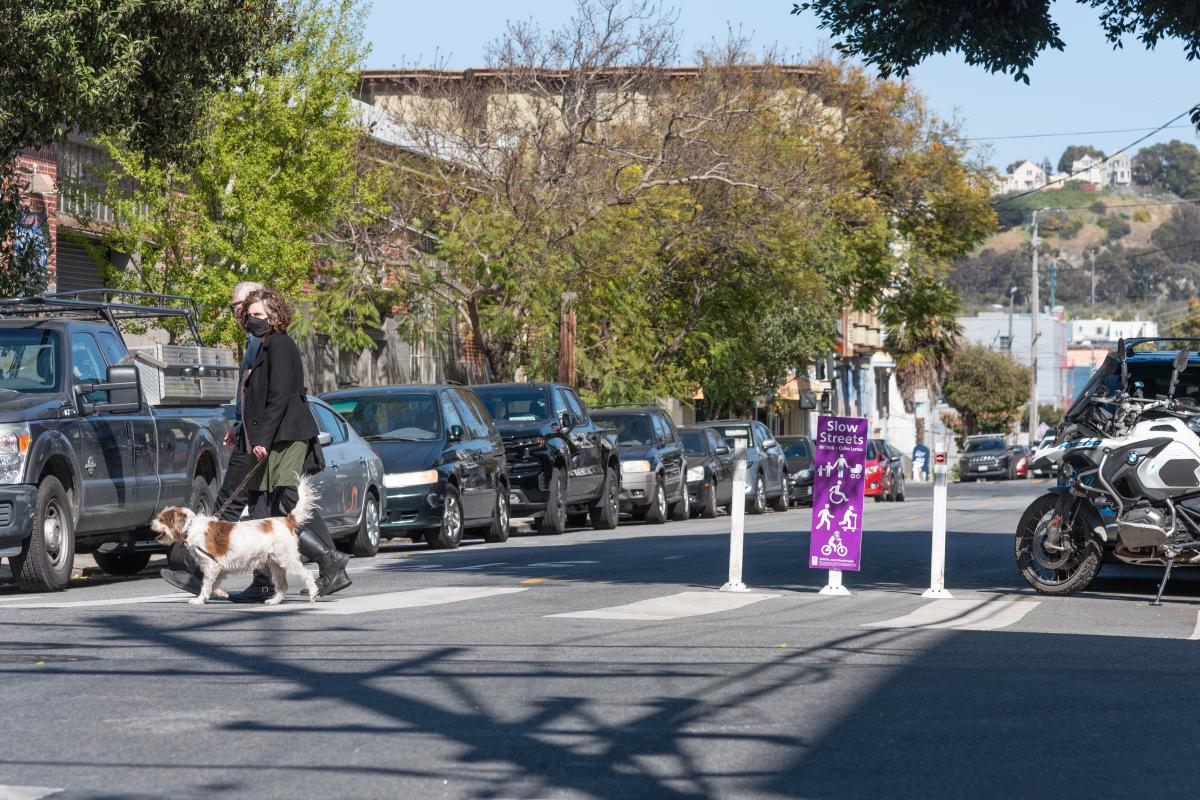
What are Slow Streets?
Slow Streets began as an emergency response to COVID-19 and the shelter in place order. At the beginning of the pandemic, with many parks closed and recreation options limited, Slow Streets provided much-needed space for people to walk and bike at a safe distance.
Slow Streets are corridors designated as shared spaces for pedestrian, bike, scooter, wheelchair, and car traffic. On Slow Streets, vehicles are limited to only local access trips and are encouraged to drive slowly to make the street safer for other users.
Slow Streets are NOT full street closures. The signage and materials are intended to limit through traffic and encourage multi-modal, accessible use of the corridors.
How should Slow Streets be used?
On Slow Streets, safety for all users is the goal. That means:
- Travel at slow speeds
- Drivers watch for all road users
- Drivers obey through-traffic restrictions/local access only signage
- Cyclists yield to pedestrians, children, and people with disabilities
- Slow Streets users make space for cars arriving/departing local destinations
- Be kind and considerate to your fellow Slow Streets users!
What do you mean by “local access only”/”no through traffic”?
Local access only means that only car trips with a specific purpose on the block are permitted. While there is no legal definition of what constitutes through traffic, we have created a set of guidelines to ensure Slow Streets remain safe, car-light spaces:
- Driving to and from a residence on the block=allowed
- Accessing a business on a particular block=allowed
- Picking up or dropping off a person or item on a particular block=allowed
- City services, deliveries, curb uses on a particular block=allowed
- Drop off/pick up for a school on or near a Slow Street=allowed
- Using the street as a cut-through to another destination=not allowed
- Driving along multiple blocks of a Slow Street=not allowed**
**EXCEPTION: Emergency vehicles may use Slow Streets for response.
How can we activate our Slow Street?
Many neighborhood groups have organized events and projects to make their Slow Streets into vibrant community spaces! Some highlights: creating art on garages that face the Slow Street, hosting Halloween walks, planning neighborhood bike rides along Slow Streets corridors. A couple things to note: Slow Streets are functional roadways for bike, pedestrian, and local-access vehicle traffic, so activities need to preserve the use of the street. (If you are interested in fully closing a street for a certain amount of time, we recommend looking into the SFMTA’s Play Streets program!). And in keeping with the importance of respecting neighbors, please be mindful of noise levels and timing of planned community activities.
What’s the plan for Slow Streets after the COVID-19 pandemic?
Slow Streets were introduced as part of the city’s response to COVID-19, and are authorized to remain in place for 120 days after the Mayor lifts the current State of Emergency related to the pandemic.
As the COVID-19 situation has continued to evolve in San Francisco, though, we have heard from communities that the purpose of Slow Streets is evolving into much more than an emergency response. Slow Streets are becoming essential spaces that meet community needs beyond the pandemic: They are places where neighbors are getting to know each other, where kids can learn to bike, and where communities can plan events along safe, low-traffic corridors. Over the past year, we have seen neighbors turn their Slow Streets into safe streets for Trick-or-Treating, organize a community bike ride along the corridors, and activate them with art and murals.
To continue to meet these important community needs, SFMTA is developing a path forward for post-pandemic Slow Streets. Currently, four corridors--Sanchez Street, Shotwell Street, Lake Street, and Golden Gate Avenue--have been authorized to remain in place following the pandemic.
To become a lasting part of the city’s infrastructure beyond the pandemic, a Slow Street corridor must meet specific feasibility criteria, be reauthorized as a post-pandemic Slow Street by the MTA Board, and complete an outreach process with the community to determine the design of lasting Slow Street materials. Engagement with communities and residents will focus on how people are using the street, and what designs and approaches will best serve their needs. This means in the future, no two Slow Streets will look exactly the same, and the signage and traffic calming treatments along the corridors will reflect local needs and priorities.
How are you evaluating the success of the Slow Streets program?
The Slow Streets team is continually collecting traffic and usage data alongside resident feedback of the program. Our recent Slow Streets Evaluation Summary Report provides a high-level overview of the data used to assess the program. In it, you can find traffic data for each of the Slow Streets, including: daily vehicle volumes and speeds; bike and pedestrian traffic counts; and assessments of spillover traffic impacts. Additionally, user feedback from extensive surveying efforts is shown.
As San Francisco moves out of the pandemic, traffic patterns are evolving across the city. Our team is committed to ongoing data collection and evaluation to assess the direction of the program and where adjustments may be needed.
Do Slow Streets work everywhere?
Unfortunately, not all residential streets are good candidates for the Slow Streets program. Streets with traffic signals, one-ways, streets containing Muni lines, and emergency service corridors all limit our ability to implement a Slow Street. Here are some of the criteria used to vet the viability of a street to being designated as a Slow Street:
Minimum criteria that must be met:
- On a residential street within the jurisdiction of the SFMTA
- The proposed street segment has no conflicts with:
- MUNI routes (including non-revenue routes)
- Emergency response corridors
- Commercial loading zones
- Streets with stop
Desirable characteristics:
- Connections to bikeways
- Streets that are relatively flat
- Streets with mostly stop-controlled intersections instead of traffic signals
- Streets with two-way operations
- Connections to essential services and commercial corridors
- A continuous and linear route
- A route that is at least 4-6 blocks long
What if I see damaged or missing signs?
We are in the process of ensuring all Slow Streets are marked with our new signage, which includes highway-grade delineators, affixed to the roadway. We appreciate your patience as we transition away from the original barricades. If you notice any issues with signage along a Slow Street corridor, you can email our Slow Streets project team at SlowStreets@SFMTA.com, or send us a message via Twitter @SFMTA_Muni. If possible, please include a photo and the intersection in question.
Other Street Closures
What is happening in Golden Gate Park?
On September 18th, 2020, new expansions to the Golden Gate Park Slow Streets program were opened up to the public. Walkers, bikers, runners and skaters can now enjoy a nearly car-free route from the east end of Golden Gate Park to the ocean. This is part of a collaboration between the SFMTA and San Francisco Recreation and Park Department.
Golden Gate Park Slow Streets begin at Stanyan Street and John F. Kennedy Drive East on the park’s eastern tip, connecting with the stretch of JFK from Kezar Drive to Transverse Drive. The route then continues onto Overlook Drive, then Middle Drive and Martin Luther King Jr. Drive to Ocean Beach, where it connects with the Great Highway, which has also been closed due to the pandemic, creating a continuous, family-friendly path from the Panhandle to the San Francisco Zoo.
What is happening in the Tenderloin and SoMa?
The Tenderloin Plan is part of a broader citywide effort that seeks to address and improve conditions in the neighborhood, with an initial focus on the 13 blocks in the Tenderloin that are most highly impacted. Implementation of the Plan will be iterative and informed by ongoing community input, with a goal of expanding to the other 36 blocks in the Tenderloin not specifically identified in the Plan.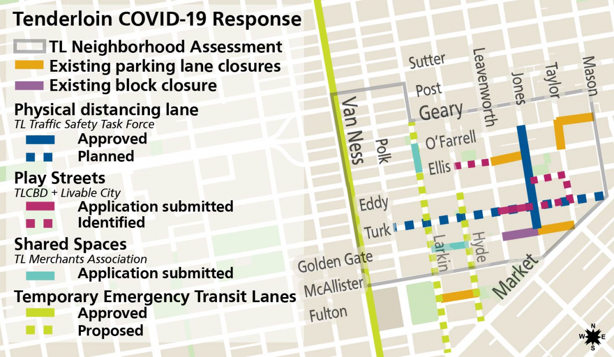
Map highlighting multi-agency and community efforts to repurpose streets space in the Tenderloin.
The Plan has eight main goals:
- Address encampments by offering safe sleeping alternatives to unsheltered individuals.
- Facilitate social distancing compliance by closing streets and parking.
- Ensure that housed residents in the Tenderloin have safe passage and access to their homes and businesses.
- Improve access to hygiene stations, restrooms and garbage disposal for unhoused individuals.
- Address food and water insecurity for housed and unhoused residents alike.
- Increase police presence in the neighborhood to focus on public safety concerns.
- Increase health services in the neighborhood.
- Increased education and outreach to residents and businesses through a ‘care ambassador’ program.
Can a commercial street be a Slow Street?
Slow Streets treatment is only appropriate for low-volume residential streets. However, the Shared Spaces program uses similar elements to create space for outdoor dining and street closures in commercial districts.