
Update:
- Our crews have implemented the new Twin Peaks configuration. The Portola gate is now open for vehicle peak access and the Burnett gate is closed for pedestrian and bicycle use only.
- For frequently asked questions on the Twin Peaks for All project, please visit our FAQ page.
- The SFMTA's recomended proposal for Twin Peaks is now availible.
Twin Peaks for All
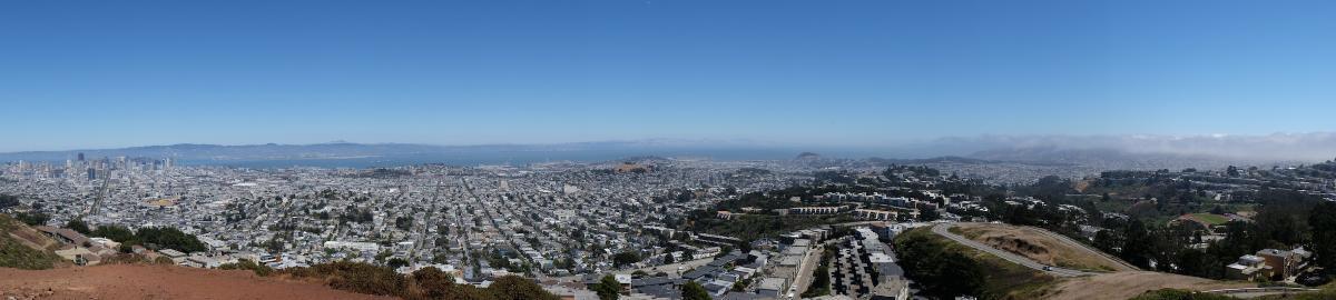
Twin Peaks is a beautiful and unique destination for San Francisco residents and visitors alike. The Twin Peaks Boulevard gates were closed early in the pandemic to reduce crowding at the lookout point parking lot. The gates were closed on the north, at Burnett Avenue, and the south, at Portola Drive. Since then, Twin Peaks Park use by hikers, joggers and people on bicycles has increased significantly with an average of over 800 visitors each weekday and over 1,100 on weekend days.
While the new park configuration received support, they are also significant community complaints, particularly from:
- San Franciscans who love the viewpoint and are unable to walk or roll all the way up the hills
- The tourism industry, for whom the viewpoint is one of our more memorable sights
- Nearby neighbors who have complained about parking, noise and crime caused by park visitors
In an attempt to address these concerns, the south end gate at Portola Drive was opened in September daily between 6:00 p.m. and midnight to provide local access to the top of the peaks for people driving. However, some unresolved issues remain, so the SFMTA is working with the community and other city departments including Rec and Park, SFPD and Public Works on new ideas to ensure access and balance needs at Twin Peaks.
Goals for a New Design at Twin Peaks Park:
- Restoring access to the viewpoint, especially for people with disabilities
- Providing a space for people walking and rolling that allows for physical distancing
- Reducing negative impacts by park users on neighbors
- Retaining the extraordinary increase in new park users by maintaining safe, continuous routes for those traveling on foot, bicycle and assistive mobility devices.
Recommendation: Open Portola Drive Gate at All Times, Close Burnett Avenue Gate
SFMTA staff are recommending a proposal for Twin Peaks access aimed at balancing the diverse needs of the community, which they selected based on park usage data, feedback from neighbors and other stakeholders, as well as a public survey with over 1,700 responses.
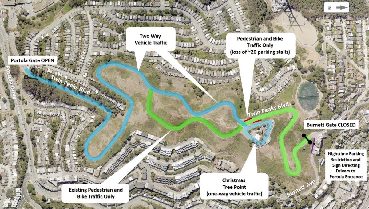
Map showing the proposed configuration of Twin Peaks Boulevard. See our website for a more detailed map or to read our report.
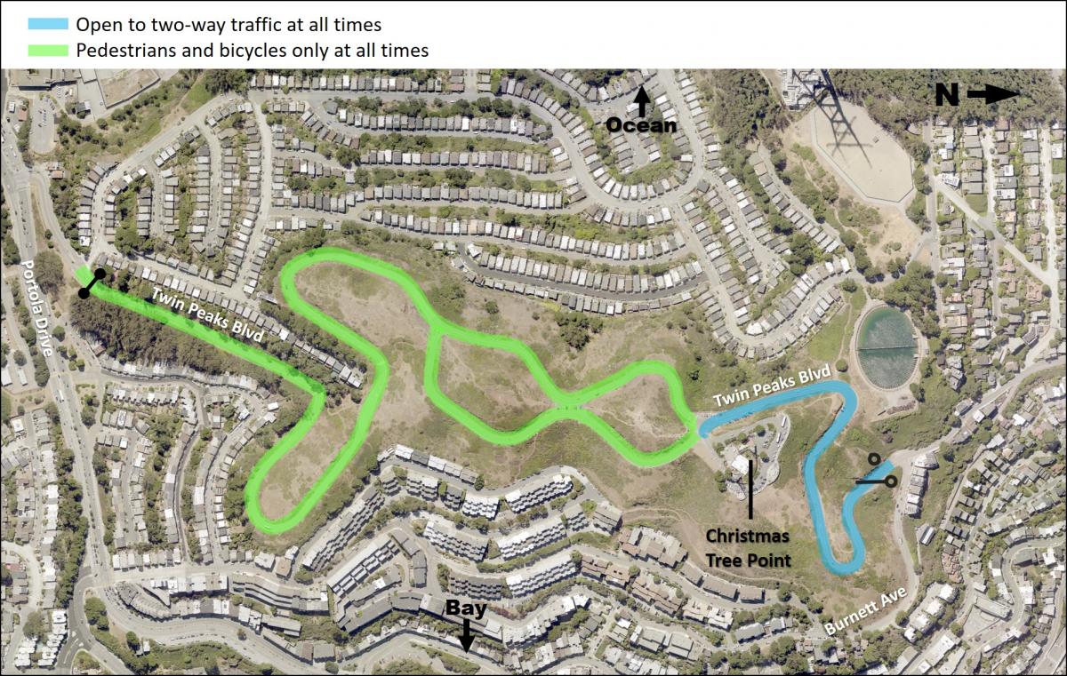
The proposal includes opening the gate at Portola Drive to traffic at all times and keeping the gate at Burnett Avenue closed. This option (also called Option 2) provides the best combination of safety and access, and addresses the negative impacts affecting neighbors.
This preferred option closes the northern Burnett Avenue gate to vehicles at all times, creating dedicated space for people walking, rolling and biking all the way to Christmas Tree Point Road.
The southern Portola Drive gate will be open to vehicles and tour buses at all times – improving access to the top of Twin Peaks for those with mobility challenges. The Portola Drive gate will also serve people walking, rolling and biking to and from Christmas Tree Point Road by way of the existing roadway shoulders and off-street paths. The recommended design does not require modifications to streets that currently restrict tour buses.
Five options were developed to achieve the project goals and reviewed by the SFMTA, in partnership with the San Francisco Recreation and Parks Department, the public, and other project stakeholders. Based on data and public feedback, SFMTA staff plans to bring the recommendation to the SFMTA Board of Directors for approval at a public meeting planned for this spring.
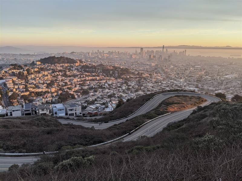
Photo: New space between Burnett Avenue and Christmas Tree Point parking lot that would be dedicated to people walking, rolling and biking. Vehicles would not be allowed at all times.
Design Options Considered:
The below options were a set of ideas that attempted to balance the needs of the community. We asked for feedback to understand how each option might work for the community. Option 2 was selected as the preferted alterative based on data, survey results and design study.
1. Burnett Avenue Option
- Burnett Avenue gate is open 24 hours, with parking and a vehicle turnaround available on Christmas Tree Point Road.
2. Portola Drive Option (recomended option after feedback, data and outreach)
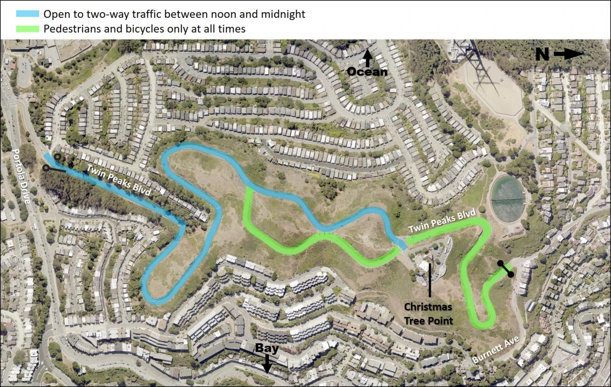
- Continue keeping the Portola Avenue gate open, extending the hours to noon to midnight daily.
3. One-Way Southbound Option
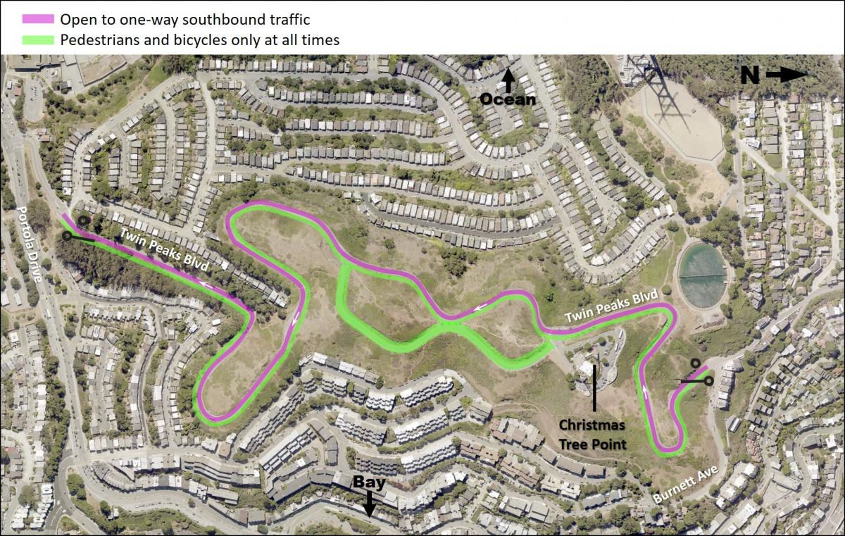
-
Implement one-way, southbound vehicle traffic, from the north gate at Burnett Avenue to the south gate at Portola Drive. Reserve the northbound vehicle travel lane for people walking and bicycling.
4. One-Way Northbound Option
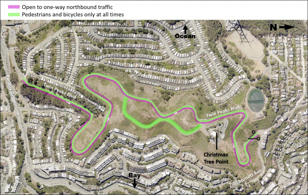
-
Implement one-way, northbound vehicle traffic, from the south gate at Portola Drive to the north gate at Burnett Avenue. Reserve the southbound vehicle travel lane for people walking and bicycling.
5. Pre-COVID Option
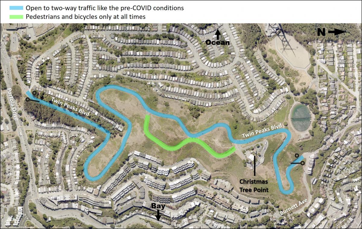
-
Open both the north and south gates, as were conditions pre-pandemic. The east side of the figure eight is reserved for people walking and biking and the west side of the figure eight is reserved for two-way traffic.