
Faster trips and safety upgrades: Learn about evaluation results from Quick-Build improvements and what's next for Geary Boulevard in our recent blog.
New trees and decorative sidewalk designs will be installed as part of the Geary Boulevard Improvement Project. Read about these community enhancements that were chosen with input from neighbors.
SFPUC began their work January 2025 to upgrade aging utilities along Geary Boulevard. Learn more about SFPUC’s sewer and water project.
For updates about SFMTA’s future transit and safety work, please be sure to sign up for project updates via email or text to stay informed about the surface work planned after underground utility upgrades are complete.
The SFMTA is working to improve transit and safety along the Geary corridor. The first phase of work, called the Geary Rapid Project, was completed on schedule in fall 2021 and resulted in significant transit and safety improvements, including up to 18% faster bus travel times, a 37% improvement in transit reliability, and an 81% reduction in excessive speeding by private vehicles.
The Geary Boulevard Improvement Project is the second phase of work, aiming to extend those benefits to the western part of the corridor between Stanyan Street and 34th Avenue in the Richmond by improving Muni’s 38 Geary bus service and addressing traffic safety. The SFMTA conducted several rounds of outreach between 2021 and 2023, asking neighbors about their priorities for Geary. We used this feedback to develop the detailed project design.
The Geary Boulevard Improvement Project, including the complete Quick-Build component, was unanimously approved by the SFMTA Board at the August 15, 2023 meeting and implemented in Fall 2023.
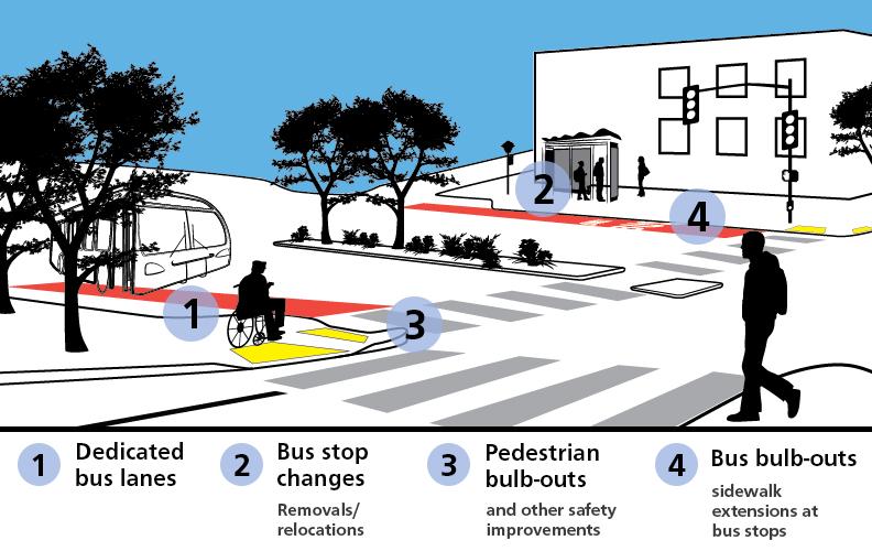
Learn more about the key project features:
- View the block-by-block project drawings (or read the accessible text version)
- Sign up to get text or email updates
- Planning
- Detailed Design
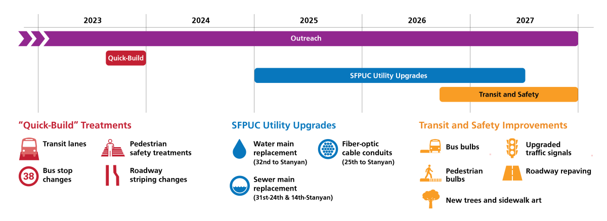
Project Timeline
The project schedule includes:
- Quick-Build installation of additional transit lanes, bus stop changes, transit signal optimization, retimed pedestrian signals to give people walking more time to cross the street and other safety improvements completed in 2023
- ~2 years to complete detailed design
- Construction coordinated at the end of SFPUC's planned ~2.5 year water and sewer utility upgrade project
Project Location
Geary Boulevard between 34th Avenue and Stanyan Street.
Frequently Asked Questions
Jump to topics using the linked list below:
1. Geary transit service is already pretty good. Why are more improvements needed?
2. How does is this project improving safety and accessibility for people walking?
3. What are the overall parking impacts?
4. How does moving a bus stop from nearside to far-side improve transit performance?
5. How does restricting left-turns improve traffic safety?
6. Are there any benefits for people riding bikes?
7. Are any trees being removed or additional trees being planted?
8. When will construction start and how long will it last?
9. Could Geary be upgraded to rail service in the future?
10. How is the SFMTA supporting businesses during construction?
1. Geary transit service is already pretty good. Why are more improvements needed?
The SFMTA has been working to improve bus service for customers through service adjustments and roadway projects such as the Geary Rapid Project between Market and Stanyan streets and the 38 Geary Transit Lanes in parts of the Richmond. Yet, Muni customers riding the 38 Geary and 38R Geary Rapid bus lines can still experience gaps in service due to inconsistent delays to buses. This can contribute to crowding and slower travel times. There is also an imperative to increase the attractiveness of public transportation in order to mitigate the harmful impacts of climate change that are becoming a part our daily reality. The Geary Boulevard Improvement Project aims to further improve bus performance. Improved transit travel time from the Quick-Build is already saving riders a collective 235 person-hours every day.
Learn more about how the Geary Boulevard Improvement Project improves transit and safety.
2. How is this project improving safety and accessibility for people walking?
The Geary Boulevard Improvement Project is a critical component of the City’s efforts to achieve its Vision Zero goal to eliminate traffic deaths. This segment of Geary is part of the High-Injury Network – the 13% of city streets that account for 75% of severe and fatal collisions. From 2010 to 2021, there were 437 injury collisions with 578 people injured and five people killed on this segment of Geary Boulevard from 34th Avenue to Stanyan Street, 145 of which were pedestrians. This means, on average, one person walking is injured in a traffic collision within the project area each month. This represents a disproportionately higher collision rate relative to the rest of San Francisco.
The Geary Boulevard Improvement Project aims to improve safety for people walking by redesigning intersections to make them safer, introducing new pedestrian bulb-outs, daylighting and expanded median refuges. In addition, traffic signals were retimed and coordinated throughout the corridor to provide more time for people of all abilities to cross safely, including near senior centers. Left-turn restrictions at some intersections reduce conflicts between vehicles and people walking, as well as improve traffic safety by increasing driver visibility and providing space for larger center median pedestrian refuges. After the Quick-Build, injury-causing collisions decreased by 1/3 in the project area.
See a comprehensive list of all proposed safety and accessibility benefits on Geary.
3. What are the overall parking impacts?
Parking loss is a trade-off for better bus service and safer streets for people walking. Almost all parking changes were made as a part of the project’s Quick-Build implementation in Fall 2023.
The Geary project team studied every available option to minimize parking loss incurred by the project. To help offset parking removals, additional parking was added to some cross streets by converting some parallel parking near Geary to angled parking. This brought the net reduction of parking down to 31 spaces, or less than one parking space per block on average.
See the complete list of parking changes by block.
We have also heard from small businesses about the importance of maintaining customer access to their storefronts. The SFMTA conducted a merchant loading survey to identify places where curb space changes, such as adding more passenger or commercial loading zones, can help meet the needs of local businesses.
The Quick-Build evaluation found that parking availability on the corridor generally remained above 1 space per block face during metered hours (except on Saturdays between 12-2pm when availability ranged between 0.7 and 0.9 spaces per block).
4. How does moving a bus stop from nearside to far-side improve transit performance?
Moving stops from the near-side of the street to the far-side lets buses get through an intersection before stopping. It also allows buses to benefit from transit signal priority technology, where buses communicate with the traffic signal to make them more likely to catch a green light. If a bus has to serve a stop before the intersection, it can’t communicate with the signal because the amount of time a bus needs to wait at a stop for passengers to load/unload is variable. Moving stops far-side also removes conflicts with vehicles turning right, which can cause vehicle queuing and pedestrian safety issues when vehicles try to pass around the bus and through the crosswalk.
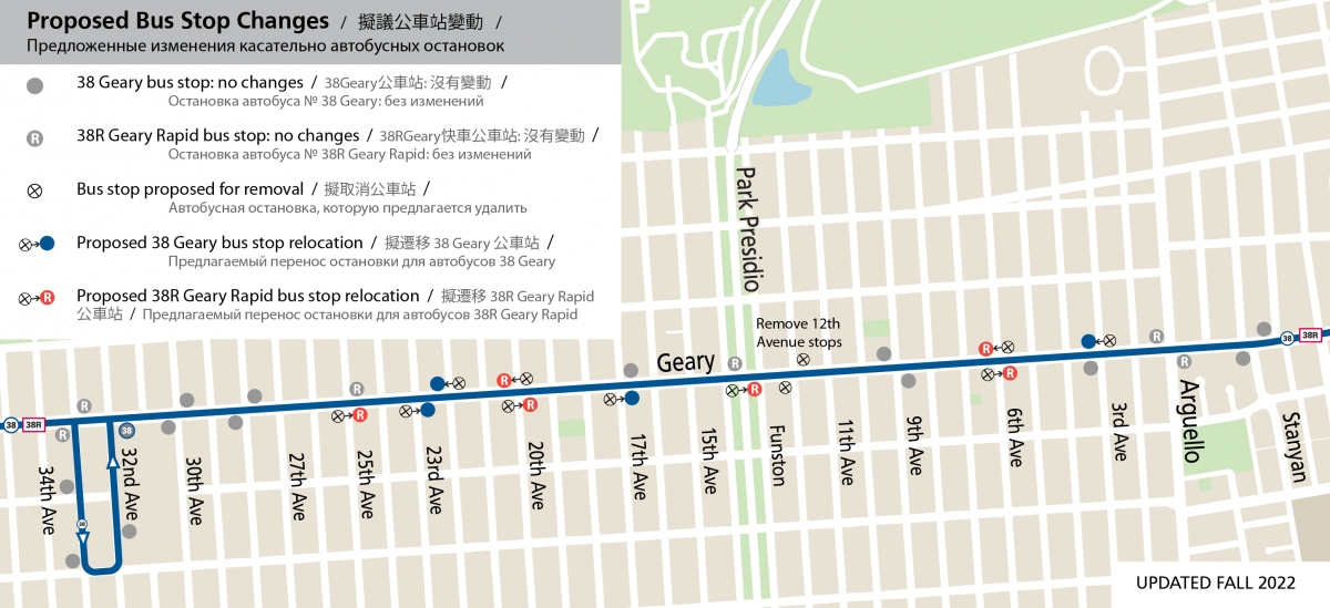
Map showing the project’s bus stop changes that were made in 2023 to improve travel time and reliability. Download a PDF version.
5. How does restricting left-turns improve traffic safety?
Before the project on average, one person was injured in a collision each month on Geary. In places where both eastbound and westbound vehicles on Geary can turn left, they often face each other nose-to-nose as they wait for a gap in traffic. When an opposing vehicle is obstructing the driver’s view, drivers have three different conflicts to consider as they make their turn: pedestrians in the crosswalk, opposing through traffic, and opposing left-turns. This can lead to drivers making quick or uninformed decisions which can sometimes lead to collisions. One tool the SFMTA can use to improve pedestrian safety is left-turn restrictions, which reduce conflicts between vehicles and people walking, and improves driver visibility.
In other locations on Geary where similar turn restrictions have been implemented, the number of reported vehicle collisions related to left-turn movements have been reduced and there have been no subsequent reported pedestrian collisions. Based on these positive results, the Geary Boulevard Improvement Project removed one left-turn opportunity among each “couplet” (where existing conditions allow both eastbound and westbound left-turns at two adjacent intersections) within the project limits. Collision history and access implications were considered in selecting which direction among each couplet is recommended to be restricted. The Quick-Build evaluation found that queues at the remaining left-turn opportunities stayed well within acceptable levels, with less than 25% of capacity used at peak hours.
Turn restrictions also create space to construct larger median pedestrian refuge islands, so that people crossing Geary have a safe place to wait in the middle of the street in case they cannot walk across the roadway in one traffic signal cycle. This is especially important near senior centers.
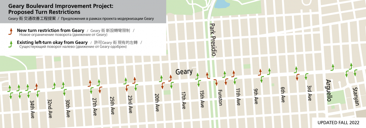
Map showing turn restrictions on Geary that were implemented in fall 2023 and places where left turns can still be made. Download a PDF version.
6. Are there any benefits for people riding bikes?
Geary is a wide street and serves high traffic volumes, therefore parallel corridors (such as Anza Street) are better designed for east-west bike routes. Geary Boulevard Improvement Project bicycle improvements focus on people biking across Geary along north-south bike routes including 8th, 15th, 23rd and 34th avenues. These improvements include daylighting and advanced limit lines, as sharrows have already been installed.
7. Will any trees be removed or additional trees planted?
Two small Victorian box trees were removed within the southwest corner of the Park Presidio greenway near 14th Avenue at Geary to facilitate the relocation of a Bay Wheels bike share station. Four new trees will be planted in the same vicinity.
On Geary Boulevard at 6th Avenue, one tree has been removed and will be replaced with five trees nearby.
The project’s community enhancement includes approximately fifty additional trees within the project area.
8. When will construction start and how long will it last?
Contractors: please visit our Info for Contractors webpage for details on project delivery and contract opportunities.
“Quick-Build” improvements—such as transit lanes, bus stop changes, left-turn restrictions and safety treatments like daylighting—were installed in Fall 2023 by City crews using paint and signs. The remainder of the project’s scope, including bus and pedestrians bulbs and traffic signal upgrades, will be constructed by a contractor after a detailed design phase.
While construction of SFMTA Geary Boulevard Improvement Project elements on their own will only take about a year, the work is being coordinated with extensive independent utility work by the San Francisco Public Utilities Commission. Many of the water and sewer lines under Geary Boulevard are over 100 years old—among the oldest 2% of pipes in the City and in urgent need of rehabilitation. Coordinating this work will minimize disruption to the community by focusing activities within one period. Construction of the utility work began in late 2024 and will last about three years, with the transportation upgrades, including final roadway repaving, occurring within the last year of work. The SFMTA has worked closely with the SFPUC to develop a construction mitigation plan to minimize construction-related impacts, similar to what has been done for past projects. Learn more about SFPUC’s sewer and water project.
9. Could Geary be upgraded to rail service in the future?
The ConnectSF Transit Investment Strategy calls for investment in a Geary-19th Avenue subway to provide fast, high-capacity service and improve regional access, but would take more than a decade to deliver at minimum. This idea is currently being studied through the Geary/19th Avenue Subway and Regional Connections Study. The Geary Boulevard Improvement Project complements such an investment by providing needed transit benefits to this busy corridor much sooner for a relatively low cost. In addition, the alignment and stations of a Geary-19th Avenue subway have not yet been determined, but are not expected to serve the entire length of the Geary corridor. Therefore, Geary bus service would continue to be an important link connecting the western Richmond District to any future rail, and buses would likely retain high ridership as a surface-level alternative, similar to the 14 Mission buses above BART.
10. How is the SFMTA supporting businesses during construction?
The project is providing support to small businesses throughout the project’s implementation. During the project’s Quick-Build implementation, the project team formed a Small Business Working Group. The group met five times to decide how to direct project funds to support businesses. As a result, the project executed two successful campaigns:
- An advertising campaign on Muni buses “Central Richmond: Everything You Need” that highlighted the diversity of small businesses in the Central Richmond.
- A lighting campaign that purchased and installed window and tree lighting at 28 Geary businesses selected via an application process. This lighting added some additional festive cheer during the holiday season and also continues to beautify the neighborhood and make Geary feel safer and inviting.
The Working Group has also been an essential voice for merchants to share their concerns and collaborate with us to make adjustments to make the project work better, like changes to loading zones. The SFPUC has been convening a similar working group during their sewer and water project construction. The SFMTA will re-convene the working group for additional support and collaboration when the project’s construction phase begins in 2026.